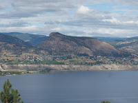
I especially enjoyed the varied surroundings, from wineries and peach trees to the South Okanagan native vegetation like ponderosa pines; we even spotted some prickly pear cactus. One way to Naramata is approximately 12km. Returning was easy as it was all downhill so hardly any peddling was required. When we arrived at Smethurst Rd, which one can follow into the village of Naramata, we had to turn around to make it back to Summerland in time to join a boating group. I can't wait to check out the next part of the trail and maybe camp some of it.
Monday, August 9, 2010
Biking the Kettle Valley Railway - Penticton to Naramata
I especially enjoyed the varied surroundings, from wineries and peach trees to the South Okanagan native vegetation like ponderosa pines; we even spotted some prickly pear cactus. One way to Naramata is approximately 12km. Returning was easy as it was all downhill so hardly any peddling was required. When we arrived at Smethurst Rd, which one can follow into the village of Naramata, we had to turn around to make it back to Summerland in time to join a boating group. I can't wait to check out the next part of the trail and maybe camp some of it.
Saturday, June 19, 2010
Seymour Valley Trailway
With a knee issue (thanks to not getting enough practice runs during my run clinic earlier in the year), I've had to resort to activities other than running and hiking to take the burden off my dysfunctional joint hence cycling. The Seymour Valley Trailway in North Vancouver was highlighted in a newspaper article last year about cycling routes in the Lower Mainland. Just to clarify things, I am not one of those Tour de France, spandex clad road racers, but rather a recreational cyclist who rides a hybrid bike on non-technical trails for fun and exercise. I really wish I'd checked out this trail earlier, because it's a beautiful cycle through forested mountains with lovely views and not very crowded despite the fine weather. The trail is a 10km (one way) paved path (wide) with two lanes for opposing traffic and modes of transport includes not only bikes but also rollerbladers, joggers, walkers and skateboarders. The surroundings are beautiful, west coast forest and creeks with a view of the surrounding mountains. The best part was the fresh air, pure and scented with the spiciness of the warming woods.
At the end of the trailway one has the option to continue to a gravel trail, more intimately embedded in the woods that follows the Seymour River and terminates at a salmon hatchery. We followed this trail and explored the hatchery, particularly enjoying the display tank with multi-levels and fry that were trying to jump to the next level. Very cute and it's amazing how fast those little guys can move. The hatchery was not accessible by a public road so it was quiet and secluded with only cyclists and hatchery employees around.
The trailway is rated easy and it was in the sense that it is paved and the elevation gain is only 80m from what I read, but there is quite a bit of "up and down" allowing me to test my cardio and then recover on a downhill. At the end of our cycling adventure our quads were tired and we realized that we're not in the best of shape. The hills are do-able, I didn't see anyone who had to hop off their bike and walk it up, but there are a few that get the heart pumping. Oh well, we have the rest of the summer to improve. It's days like today that remind us why they call BC the best place to live, because sometimes it's hard when it's pouring rain and the average house price is nearly a million dollars.
Sunday, October 4, 2009
Garibaldi Lake Aug.29/09
Finally got around to doing this Lower Mainland classic on a beautiful Saturday in August. The hiking books warn about the popularity of this hike and indeed, I think the parking lot was busier than Metrotown, so if you go on a sunny weekend in the summer I highly recommend getting there as early as possible before the swarms hit. Note that it is pay parking.
To reach the lake and meadows you follow a well maintained, wide trail through the forest consisting of a series of switchbacks for a steady incline. There were some signs warning of a bee's nest near the trail and I managed to get stung by a bee in a bad mood, one too many hikers crossing her flight path I guess. It was a steady slog to the top but watching the campers hauling all their gear up the trail made me thankful for my small backpack of water and lunch.
The meadows were pleasant with a view of Black Tusk in the distance and we stopped at a creek to refill our water bottles. Of course the true gem was Garibaldi Lake, the turquoise water stunning against the glacial backdrop and vibrant fireweed sprouting here and there. We toured through the campground which looked pretty neat with walk-in tent sites. It fills up quickly as signs on the way up warned that the campground was usually full by early afternoon Saturdays. On the way down I was surprised by the number of campers still heading up the trail since it seemed the campgrounds were full.
Being my first serious hike of the season, my feet were very sore by the end of the hike due to the distance covered.
Time to complete: Approx 6 hrs and we took ample breaks at the meadows and the lake.
Level IMO: Moderate. Climbing the switchbacks got my heart rate up but my hiking buddy wasn't as affected.
Elk Thurston Chilliwack Oct.3/09
This is the first hike I've ever done so late in the season as I normally call it quits come September. This hike starts as a fairly gradual climb through the forest, first through rainforest and as you climb the trees grow smaller, less undergrowth and drier - maybe this is second growth forest? The trail then turns quite steep and is a good workout, almost reminiscent of the Grouse Grind and I started to worry that I wouldn't be able to get back down as the trail grew steep. No scrambling was required.
Finally we came to the top of Elk Mountain where there were great lookouts from the boulders, then we continued on to the mountain ridge with spectacular views of the Fraser Valley; being at the end of the hiking season a few of the neighborining mountains were covered with a dusting of snow adding to the splendour. The trees along the ridge were covered in ice droplets which were starting to melt in the afternoon sunlight and made a lovely ethereal sound as they melted and tumbled down the branches to the ground. It was cold at the top and the ground was too damp to sit on so we had to stand. My fingers were freezing and numb within a few minutes. This ridge is where the paragliders jump off.
Feeling cold in our shorts and lacking gloves, not to mention we had intended to do an easy-moderate hike less than four hours long, we decided to forgo continuing on to Thurston mountain which was at the end of the ridge and instead started our descent. I can't imagine trying to come down the steep sections without poles - I had my hiking stick and Kevin gave me his wood walking pole as I can be unsteady on my feet on downhill sections. I think the issue is not so much the grade but there are no steps and rainwater seems to follow the path, washing a fair bit of loose gravel down the center of the path.
One thing to note, the trail seems quite popular with downhill mountain bike riders as we passed at least six people pushing their bikes up the hill so be alert for bikers flying down the hill as you might have to jump out of the way quickly. One of the bikers told us that the view of the sunset from the ridge is spectacular.
Time to complete: approx 3.5 hrs with a short break at the top
Level IMO: moderate with some strenuous parts - depends on the fitness level of a person, I had to stop several times to get my heart rate down but Kevin was fine and his heart rate wasn't that high. Would recommend bringing hiking poles to make it easier on the knees.